
Updated on 27 March 2026
This page lists the improvements and new TerraIndex features rolled out in March.
Below you will first find the highlights of this release.
Scroll down for the full overview of all improvements and changes.
Highlights
Environmental Field: improved battery use
The app now uses less battery thanks to improvements in GPS use and background processes.
Environmental Field: iPad app crash fixed
Uploading many or large images could cause the app to freeze completely or crash. Occasionally this also happened when the project contained no photos. This has been fixed
Environmental Field: improved camera function
You now take higher-quality photos (at least 5 MP) including metadata, making images sharper and more useful in reports. Photos are saved immediately after capture without extra confirmation.
Photos you have taken appear immediately in a clear carousel so you can quickly check what you have captured. You can easily browse, delete or rotate photos from this overview.
You can also choose the camera in advance using a dropdown. Camera operation has been improved, including a visual flash when taking a photo and more consistent interface behaviour.
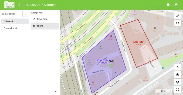
Environmental Field: boundaries on the map
You can now use GPS to draw an investigation site boundary on the map. Multiple boundaries can be drawn to represent sublocations.
Environmental Field: synchronising with or without photos
You can now choose whether to synchronise a project with or without photos and documents.
Working at a site with a poor internet connection? Synchronise just the project data first, without photos and documents. The office gets immediate access to the main data while you can quickly continue in the field. When the connection improves, you can synchronise the photos and documents as well.
This is also useful when no new photos or documents have been added, for example during an additional sampling round. Skipping these makes synchronisation faster.
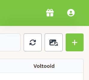
There are two synchronisation buttons in the app:
• the left button synchronises without photos and documents
• the right button synchronises the entire project including photos and documents
This gives you more control over synchronisation and saves time in the field.
Full overview
New features:
TerraIndex User Management
- The administrator can now see the last login date and time in the TerraIndex User Management user table
Environmental Field
- You can now use GPS to draw an investigation site boundary on the map. Multiple boundaries can be drawn to represent sublocations
- You can now choose whether to synchronise with or without photos
- The updated camera supports higher-quality photos (at least 5 MP), including metadata, with immediate saving and a carousel overview of captured photos.
Technical improvements
- Various technical improvements have also been made. These help implement future changes more safely and prevent errors.
- Technical improvements make it easier for Support to identify where something may be going wrong
Bug fixes:
Reporting and export
- SIKB code mappings for nitrate and nitrite added so these parameters are correctly included in SIKB-compliant exchanges.
Environmental Web
- KLIP files, used in Belgium, are displayed on the map again.
Environmental Field
- KLIP files, used in Belgium, are displayed on the map again.
- A pop-up appears when leaving a field without saving. Its buttons have been changed to clearly distinguish continuing without saving from going back to save.
- Leaving a form with missing data displayed the wrong pop-up; this has been fixed. A warning now indicates that data are missing
- Removing the bottom layer of a measurement point or changing its depth now also updates the measurement point depth automatically.
- Only a water matrix can now be selected when taking water samples
- Only an air matrix can now be selected when taking air samples
- Last-used and default values work correctly again when filling in fields
- Synchronisation could fail when a child item in a project was deleted or replaced. This has been fixed.
- The old and new positions of a measurement point are clearly distinguishable again when creating it
- Photo names are visible below the photos
- The 'Peat amorphicity' field has been added
- Date fields are now easier to fill in
- Clearer messages when leaving a page without saving should prevent data loss.
- Water sample fields are again ordered colour – colour intensity – odour – odour intensity. Translations, including pop-ups, have been corrected for all languages
- Coordinate system is translated correctly again
- Loam is translated correctly again
- Two fields had the same name when entering a soil sample; this has been fixed
- Optional fields were marked as required when entering a series for water samples. This has been corrected
- Multiple barcodes can no longer be scanned for a single sample
- The 'mottling colour' field has the correct label again
- When measuring with GPS, coordinates and accuracy (HDOP, PDOP, VDOP and satellite count) are now displayed and automatically saved at the measurement point. An additional Accuracy field for internal GPS provides better insight into measurement quality.
- The GWS pre-pumping series (cm-ref) has been renamed. The stable value after pre-pumping is now also visible in the series, making it clearly available before sampling
- Scanning the same barcode twice for different samples now triggers a message
- The table overview shows the correct barcodes again
- The first synchronisation on Android could produce an error stating synchronisation could not be completed. This has been fixed
- After synchronisation, project data could disappear from the overview and only be found in the online backup. This has been fixed
- Backups are now always created successfully, including when local data contain errors, because a raw copy of local storage is automatically saved in the user folder
- Synchronisation problems after logging in offline have been fixed. The app now handles network status correctly and avoids errors when loading new items
- The photo screen on iPad mini is now correctly displayed in full screen and the close button is visible again, making photos easy to view and close
- Improvements to GPS use and background processes reduce battery consumption
- Commas in numeric fields are now automatically replaced with decimal points so values are saved correctly regardless of input
- An issue where creating new layers could cause synchronisation errors has been fixed
- An issue where copying a measurement point and deleting a layer could cause incorrect or duplicate samples has been fixed
- Synchronisation now works correctly even when some data are missing or invalid
- The matrix field is now required for soil field samples and is filled in automatically with a default value
- A maximum of 25 projects can now be synchronised locally at once, keeping synchronisation fast and the file small enough to email if needed. A warning appears if you try to synchronise more than 25 projects at once
- Uploading many or large images could cause the app to freeze completely or crash. This has been fixed
- Sometimes not all projects covered by all licences accessible to a user were retrieved. This has been fixed
- Duplicating a field sample now sets the date to today by default
- You can now switch smoothly between tablet cameras again
- Barcode scanning in large projects could be slow due to the check for duplicate scans. This has been improved
- When placing a grid on the map, you can now enter negative coordinates and change values without an error
- The cursor now stays in the correct position when editing text fields instead of jumping back to the beginning
- M50 is now available in Details as well as as a Stiboka field
- The date picker could open when creating a series while entering air samples. This has been fixed
- Each borehole or measurement point now shows the description procedure used. The default is NEN5104, with the option to enter NEN6693
- You can now choose whether to synchronise with or without photos
- Duplicate barcodes are now preserved in laboratory orders for Acmaa so they can be processed and reported correctly
- Adding a monitoring well to a measurement point automatically changes the type to monitoring well
- The barcode scanning text has been clarified to indicate that multiple barcodes are being scanned within one field sample
- Water samples now include both date and time
- Photos and thumbnails are displayed and opened correctly again
- The number of samples to generate is now recalculated automatically when you change the starting depth
- You can open multiple KLIC files on the map without problems again
- The text 'scan water samples' has been updated in all languages
- Switching back to landscape after portrait mode on an iPad could distort the display. This has been fixed
- Projects with an invalid or missing template now display fields correctly in Field again
Archaeology Field:
- The artefact type field works correctly again
- Project exports did not include all fields required for SIKB01012, and a notification appeared when this happened. This has been fixed: the fields are now exported.
- Adding a trench to a project could cause an endless update loop. This has been fixed.