
Highlights
1. Explore your project in 3D or as a cross-section
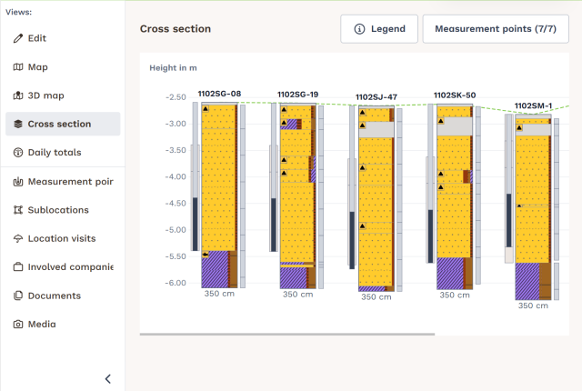
TerraIndex Field now offers two new project views. View the soil structure across multiple measurement points side by side in a cross-section, or explore your boreholes at their actual locations on an interactive 3D map. Both views include soil layers, samples, monitoring wells and groundwater information.
2. Edit contours directly on the map
You can now adjust an existing contour without having to delete and redraw it. Simply select the contour and move its points to the correct positions.
3. Improved tables in TerraIndex Archaeology
Work more efficiently in Office with improved filtering, multi-column sorting and adjustable column widths. You can also select multiple rows at once, for example to print find labels or assign finds to a box. Your personal table layout is saved.
4. New map layers for France and Spain
New background maps are available for France and Spain. BRGM map layers have been added for France. In Web, you can now also access maps and aerial imagery for Spain from the Institut Cartogràfic i Geològic de Catalunya and the Instituto Geográfico Nacional.
New
Environmental Field
Cross-section: A new project view displays all measurement points side by side, including soil layers, samples, monitoring well components and groundwater levels. This allows you to examine the soil structure across the entire site without opening each measurement point separately. You can access the cross-section from the sidebar, alongside Map and Daily Totals. The view also works offline.
3D map: A second new project view displays boreholes as columns at their actual coordinates on a background map. You can rotate, tilt and zoom, and use the display panel to show or hide layers, monitoring wells and samples, and adjust the vertical exaggeration (10x by default). This view is also available in the sidebar.
Field on mobile phones (pilot): Field now has a layout designed for phone screens. It is currently enabled for two pilot companies only. Nothing changes for other users.
Sampling workflow on mobile phones (pilot): When opening a project, you can choose between 'Describe measurement points' and 'Sample monitoring wells'. The second option displays all monitoring well filters, including the measurement point name, filter interval and most recent sampling date, without having to navigate through individual measurement points. Your selection applies per project per day, and you can switch at any time.
New fields
Air sample: Negative pressure (hPa) after sampling, H₂S (ppm) after sampling and Lower Explosive Limit (LEL, %) after sampling. In French, the explosivity fields are now labelled 'LIE (%)' and 'LIE (%) après échantillonnage'.
Air sample: Tubing length (m) and tubing material (PTFE, HDPE, PP, FEP or RVS).
Water sample: PID reference.
Measurement point: D95 (numeric value).
Bottle: Intake point depth (cm-ref).
Layer: Stratigraphy.
Map
Spanish map layers in Web: A new Spain group contains three maps: the base map and aerial imagery from the Institut Cartogràfic i Geològic de Catalunya, and maps from the Instituto Geográfico Nacional.
French background maps: Map layers from BRGM are now available.
Edit contours: You can select a contour on the map and move its points instead of deleting and redrawing the entire contour.
Show or hide contours: You can independently show or hide the project contour and sublocation contours. Your preferences are saved.
Measurement point type legend: The map now includes a legend showing the icons for different measurement point types.
Sublocation area: The area of a sublocation is automatically calculated and filled in based on the contour drawn on the map.
Archaeology
Split samples by Sample Type (KNA): When splitting a sample, you can now select Sample Type (KNA), Material Category or both. For field finds, Material Category remains the available option. The split find is named using the original sample name and a short code, for example M2.C14-Monster. The delivery note validation accepts these names.
Additional attachment classifications: You can now classify attachments as Sketch, Correspondence, Drawing, Daily Report, Weekly Report, Evaluation Report, Specialist Report or Final Report, with Dutch and English labels. Existing attachments retain their classifications.
Town/city in project details: A new Town/City field is available below Municipality, with a searchable list of locations. The selected location is included in the SIKB XML export and displayed in the SIKB Excel report. The export can still be completed without a location.
Documents attached to records: You can now upload and download Word, Excel and PDF files in the file field. The file type is automatically identified by its extension. Documents appear as clickable icons, while .gml files are displayed as map layers.
Exports
NEN 5104 correction in the SIKB 14.9 export: A new option in the export window allows TerraIndex to make minimal corrections to layer descriptions that do not comply with NEN 5104, so they pass BRO SAD validation. Only non-compliant codes, ordering and separators are adjusted. The rest of the text remains unchanged, and the original layer description stored in TerraIndex is not modified.
Improved
Environmental Field
Bottle generation: In the bottle generator for water and air samples, you can specify the number of filtered and unfiltered bottles separately, allowing you to generate all bottles at once. The Filtered yes/no field has been removed.
Photo size: You can choose whether photos are saved in a small or large size. Small is the default setting.
Measurement point depth: When you change the depth of the bottom layer, the measurement point depth is updated accordingly.
Archaeology
Search by artefact type: The Artefact Type list contains the complete SIKB code list from July. You can search by name or ABR code, with up to 50 results displayed instead of 5. Searching long lists no longer causes the screen to freeze. On split finds, the artefact type fields are now positioned between Material Type and Details.
Improved tables in Office: You can sort by multiple columns, adjust column widths and use improved filtering. Your table layout is saved per user. With Shift-click, you can select a range of rows at once, for example to print find labels 200 through 300 or assign multiple finds to a box in a single action.
Attachments in the delivery note: Attachments classified as Drawing, Daily Report, Weekly Report, Evaluation Report, Specialist Report or Final Report are included in the delivery note XML and media ZIP file. They are stored in folders named after their classification. Map layers are included as GML files. Sketches and Correspondence are not included.
Environmental Reporting
Stratigraphy is now displayed on the borehole log in the same way as Horizon: at the top of the first layer where the stratigraphy begins.
The Water Sample tab in the project data dump contains four additional columns: start time and flow rate at the beginning of sampling, and end time and flow rate at the end.
Environmental Office
Series entry is now available for tile-based data entry in Web.
Import functionality has been moved from the old import tool to Web.
Other
The message displayed when taking over a licence has been updated.
Fixed
Environmental Field
Photos taken in Field were being saved as very large files. Photo storage has been adjusted.
When entering a water or air sample, it was possible to select soil as the matrix. Water samples now only show the seven water types, while air samples only show outdoor air and soil gas, within the options allowed by your template.
When selecting a measurement point without a date after one with a date, the previous measurement point's date was displayed. An empty date field now remains empty.
Several issues in the mobile phone layout (pilot) have been resolved, including menus remaining open after using the back button and text overlapping other interface elements.
An incorrect unit was displayed for monitoring well depth. This has been corrected.
Archaeology
In Office, filtering a Barcode column caused an error, preventing users from filtering by barcode. This now works in the same way as other text columns.
Two attachment classifications had incorrect names: 'Actieplan' is now 'Plan van Aanpak (PvA)' and 'Requiermentsspecificatie' is now 'Programma van Eisen (PvE)'. Existing attachments retain their classifications and display the updated labels. Exports continue to use the same codes.
Deleting a find that had been split also deleted its split finds. The split finds are now preserved.
Environmental Lab
When importing SIKB deliveries, the latest delivery date was taken from the first customer instead of being determined separately for each customer. This now works correctly for each customer.
Importing certain laboratory results in SIKB 14 format could fail. This has been resolved.
Map
KLIP files in the new Belgian format were not imported or displayed on the map in Field and Web. This now works again.
Other
The sublocation was missing from the Soil Information table view. It is now displayed.
Importing files could result in an error message. This has been resolved.
Good to know
Archaeology – delivery note: The media ZIP file has a new structure. Attachments are now organised into folders by classification instead of being stored directly in the ZIP file. Check that your attachments have the correct classifications. Attachments classified as Sketch or Correspondence are not included.
SIKB 14.9 export: A layer description that does not comply with NEN 5104 now blocks the export instead of generating only a warning. You can enable the option in the export window to allow TerraIndex to correct the deviations. This option is disabled by default for each new export.