
This page lists the improvements and new TerraIndex features rolled out in January.
Below you will first find the highlights of this release.
Scroll down for the full overview of all improvements and changes.
Highlights
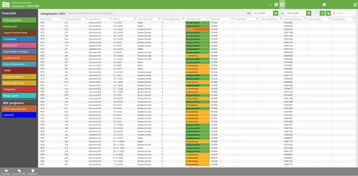
Environmental Office: laboratory orders table
In the table of all laboratory orders, you can now change the column order and choose which columns are shown or hidden. Your preferences are remembered when you leave.
Environmental Field: NEN-ISO 14688 texture input
A new texture input variant is now available: StiBoKa:


Environmental Field: sublocation boundaries
You can now add and edit sublocation boundaries on the map. You can also display the map in full screen.


Full overview
General
- The servers running TerraIndex have been upgraded to newer hardware so we can deliver better performance.
New features:
Environmental Office
- In the table of all laboratory orders, you can now change the column order and choose which columns are shown or hidden. Your preferences are remembered when you leave
Environmental Field
- Pressing the plus button while already creating an item now saves the current item and lets you create another immediately
- Groundwater and air sample calculations for France and Spain: the pumped volume and the volume that must be pumped before sampling are now calculated automatically
- You can now enter texture according to NEN-ISO 14688
- Exchange using a TerraIndex domain instead of a Microsoft server domain
- New map layers added for France
- All packages used in Field updated
- Your five last-used entries for special constituents are remembered
- You can now enter layer texture according to STIBOKA
- You can now use the "-" character even if the keyboard does not support it
- Creating and editing sublocation and project location boundaries is now possible
- The area is calculated automatically when drawing or editing a sublocation boundary
- The application loads faster following an update to dynamic importing of application information
- You can now use the map in full screen
Archaeology Office
- Additional security for server calls
- New Extra Fill entity under "Feature and Fill"
Archaeology Field
- Automated tests made more stable so errors are found earlier
- New Extra Fill entity under "Feature and Fill"
Bug fixes:
Environmental Office
- Map labels for measurement points were difficult to read against a white background; this has been fixed
- Substance groups are now sorted alphabetically when analysis results are entered manually
- Correct Spanish translation added for the "Dry monitoring well" field
Environmental Field
- The filter interval was always required even when the template did not require it; this has been fixed
- Special constituents follow the field template again
- Bottles are correctly updated again when created before a water or air sample
- The internal GPS always stored elevation even when the user disabled it; this has been fixed
- When moving a measurement point on the map, the old and new positions are clearly distinguishable
- Using the map ruler and then clicking a measurement point selected that point and removed the ruler lines; this has been fixed
- After selecting a MarxAct GPS, you can now change it to another again
- Automatic zoom to sublocation and project location zoomed in too far when the boundary was too large; this has been fixed
- Lists are correctly updated again when switching a layer texture description from ISO to NEN-ISO
- Column widths in NEN-ISO 14688 were not always correct, causing unusual formatting; this has been fixed
Archaeology Office
- Data validation is no longer skipped when a particular value is empty
- Incorrect translation of the "toonbaar" field corrected
- The server could create duplicate items when they were first created; this has been fixed
- Find label types are now sorted alphanumerically
Laboratory communication
- The same barcode was sent repeatedly for composite samples when exchanging with Eurofins. A laboratory system update no longer accepted this. This has been fixed